Kings Lynn Kettle smockmill |
 |
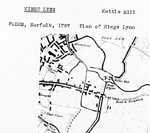
Faden's plan of Kings Lynn 1797 |
Kettle Mill stood by the East Gate to Kings Lynn in the northeast corner of the town on the River Gay, and once supplied the town with water through the New Conduit, hence the name of Conduit Street. The Bishop of Lynn built a cornmill on a tributary of the River Gay close to St. Nicholas' church for the benefit of his Newland tenants but this mill had gone by the end of the 1400s. The next mill in the area was originally horsepowered and was in operation by the beginning of the 1400s, its purpose being to draw water from the river (in kettle-like containers) to supply the town's freshwater conduits, one of the earliest of which ran from the Kettlemill down Damgate to Gresemarket, with a connection south to the Saturday marketplace. It was possibly in this vicinity that a fulling mill was built in 1393-1394. Later Kettlemill was used as a coal fired electricity plant but was eventually demolished to make way for the offices of the Local Drainage Board. |
Kettle Mill does not ever appear to have ever been a manufacturing mill. However, at one point during its rich and varied career it was certainly water driven as well as wind driven. The first record shows it as being a building housing lepers. It then took on the role of a water pumping station to supply the town before becoming a coal fired electricity station. In the 1990s it became the headquarters for the Drainage Boards. |
The windmill was built as a smockmill and had a stage. |
In 1682 the common dike was recast & a windmill erected whereby the water was raised by means of tubs or barrels from the river to a reservoir or "condyte of receipt", a wooden tank in a round tower of the town wall. |
When James de Belvaco (or Beaufoe) the son of Bartholomew de Belvaco a foreign merchant residing here was Mayor he witnessed a Deed granting a plot of land sides 122,91,79 and 115 feet called the “LAZAR HILL” to Alexander Kelloc (otherwise Alan de Kele) a Burgess in trust for the corporation of Lenne 1271 with the consent of the Brethren. Sir Richard de Sulgrave, The Master of The Order of St Lazarus of Jerusalem at Burton Lazars (Leicestershire) acted as Grantor. The purpose was for use of those suffering from Leprosy, purported to have been brought back from the Middle East by the Crusaders and forcibly detained in a Lazar House. The Lazar Hill as it was then known is still in the hands of the Corporation and until 1899 it was the site of the town’s Waterworks which was originally an Inclusae or freshwater pond in the vicinity of the Gaywood River, a reserve of water for use in an emergency. Note here that there is a range of low chalk hills about nine miles East of Lynn called the Ketel Hills which could well have been the source of the water thereabouts feeding into the Gaywood river. Also a Weir in a river formed for the trapping of fish was termed in Saxon times a kiddle or kettle. Well comes from the Anglo Saxon verb wellan to flow. Hence Kettlewell may signify flowing waters at the weir. |
The Kettlemill was operated by a windmill in 1682 and was then water driven to a storage tower with a lead cistern in the Red Mount Chapel. A water engine was then in use driven from an artificial waterfall during the 18th Century. A rudimentary steam engine, on the Newcomen Principle was tried which did not last long due to the cost of coal etc and the lack of maintenance. The inventor of the system is said to have been one Peter Morrys a Dutchman and his system was adopted not only in Hull and other large towns but in the Metropolis where several of the tree pipes were dug up in the area of Marble Arch, elm being the favourite wood as it was more capable of standing up to conditions and pressure than cheaper timbers. Several of these tree pipes have fairly recently been unearthed New Conduit Street dated early 19th Century. |
 |
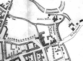
Burnet's plan of Kings Lynn 1846 |
Water came from the Kettlemills on the Gaywood river, in 1829 a new mill was built and by 1852 iron pipes were laid throughout the town. |
 |
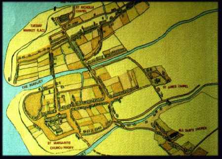
Map of Kings Lynn in 1240 |
1682: Mill built |
If you have any memories, anecdotes or photos please let us know and we may be able to use them to update the site. By all means telephone 07836 675369 or
|
| Nat Grid ref TF62302050 | Copyright © Jonathan Neville 2007 |